Tuesday, June 28, 2011

Beartrap Fork - Big Cottonwood Canyon


Beartrap fork is located up Big Cottonwood Canyon. to get to the trail head go east on  Big Cottonwood Canyon Rd.(7200 S.) 10.5 miles up the canyon past the spruces campground. The trail head is on the North side of the road, there is a small gate in front of an old access road, the trail starts behind the gate.
Click here for directions to the trailhead. 


The first part of the trail is a little difficult to follow it follows an old jeep trail with a couple of switchbacks and then intersects with another old jeep trail. Stay on the main path and you should make your way to the first stream crossing. We found the water running really high and fast so be careful as you cross. the trail then heads up the canyon mainly following the stream.
One of the many Stream crossings

Joel crosses an old dead tree


Ski lift from the Canyons Ski Resort in Park City

A view of Park City from a distance

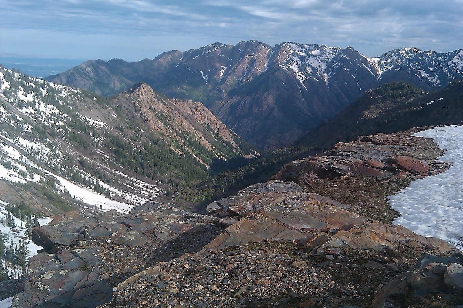
A Beautiful view of the Ridge dividing Salt lake and Summit counties


View Beartrap Fork in a larger map

Tuesday, June 21, 2011

Neffs Canyon

Neffs Canyon is one of my favorite hikes.
We hiked this trail on June 21st 2011, normally most the snow would be gone by then but, due to a very wet spring, we had to do much of the hike in snow. As we usually do we began early (around 6:30) the trail is very well maintained and easy to follow. Because of all the snow and excessive runoff we had quite an adventure trying to find our way around parts of the trail that were flooded.  The hike is moderate with the last .25 mile or so becoming strenuous. Much of the hike is through the Mt. Olympus Wilderness area. We stopped at the meadow, the trail continues from there and can be a great way to explore the many trails in the wilderness area.


Total Distance: 3.4 mi 
Total Time: 2:42:06
Moving Time: 1:15:25
(one way) 6.8 miles round trip


Max Speed: 11.67 km/h (7.3 mi/h)
Min Elevation: 1685 m (5528 ft)
Max Elevation: 2385 m (7826 ft)
Elevation Gain: 876 m (2874 ft)
Max Grade: 5 %
Min Grade: -1 %
Recorded: Tue Jun 21 06:30:02 MDT 2011


View Neffs Canyon 6-21-11 in a larger map

Thursday, June 16, 2011

Lake Blanche

Frozen Lake Blanche covered in snow, rare for June.

The Lake Blanche trail starts about 4 miles up Big Cottonwood Canyon. Parking is on the right side of the road just before the "S curve" at the Mill B parking area. On our way up the Canyon we saw a large moose standing right next the road blocking our turn into the parking area. We waited for him to cross the road and proceeded to the trail-head. What a great way to start of the morning.

For Directions to the trail-head click here.
The Stream was flowing high

The trail starts on the East end of the parking lot and follows the Creek on a paved walkway for the first 1/4 mile. The trail  splits off to the right just before a bridge that crosses over the creek that flows down from the lake.  The well maintained dirt trail to Lake Blanche begins on the west side of the bridge and is signed.  From here the trail is easy to follow and leads directly to the lake. The trail is a very manageable climb for an intermediate Hiker until the final climb before the lake.  The last 1/2 mile is a little more difficult especially for us because the ground was covered in snow. When we arrived at the lake we found it frozen and covered in snow. Located just to the west of Lake Blanche is Lake Florence and Lake Lillian. 
Looking back down the trail towards Mount Olympus.


The setting around Lake Blanche is Beautiful, the perfect alpine setting. We found complete solitude which isn't normal for this time of year. 
 (I did this hike on 19June2009 and it was crowded on the way down the trail.) As I sat down to take in the scenery and enjoy a granola bar I was greeted by a few Potguts (ground squirrels) that seemed to know what I was eating. I guess they are no strangers to human interaction.


 One of the great draws of the lake is the abundant wildlife and today was now exception in addition to the moose at the trail-head we also had a close encounter with one on the trail. The 2nd moose stood up about 15 feet away from us  as we headed up the trail. We also saw mule deer and many birds, I'm sure this hike would be a bird watchers paradise. 


Sundial Peak above lake Blanche
Overall distance on the hike was just over 6.5 miles round trip we had a total hiking time of 4 hours maybe 3.5 of that actually moving. The map below is of the Mill B trail-head up Big Cottonwood Canyon.


View Larger Map

Friday, June 10, 2011

Bells Canyon Waterfall

Bells Canyon is a wonderful hiking spot easily accessed from Sandy, Utah. There are 2 main trail-heads on located on Wasatch Blvd. about 10200 south. Click here for directions to this trail-head. Parking is on the East side of the road and the trail starts at the north end of the parking area. The second trail head is off Little Cottonwood Canyon Rd. Click here for directions to this trail-head. The parking for this trail is located on the south side of the road and the trail starts at the East end of the parking area.


View Bell Canyon 6-10-11 in a larger map

Tuesday, June 7, 2011

Grandeur Peak from Church Fork


Click to enlarge panorama atop Grandeur Peak


Grandeur Peak from Church Fork
Church Fork is the easiest and most accessible trail-head to hike Grandeur Peak. The trail head is at the end of the Church Fork picnic area about 3.2 miles up Millcreek Canyon on the North side of the road. if you reach the Millcreek Inn you have gone to far. For directions click here. The gates to the picnic area are open from 7 am til 10 pm during the summer. On the day of our hike the gates were closed do to excessive spring runoff in the canyon. If the gates are closed hike the additional 1/4 mile through the picnic area. The trail-head is well maintained and there is parking available. Don't park in the picnic area.


Extra spring runoff flowing from church fork


The beginning of the trail is a moderate hike through a heavily forested area of the canyon after a short distance it intersects with the Millcreek Pipeline trail, make sure you continue heading north across the other trail. The trail is very easy to follow until you get closer to the peak. A little over a mile into the hike the trail turns to the left and climbs out of the wooded area through a series of switchbacks. The surrounding area is now primarily scrub oak and exposed rock. There are a few areas on the trail where the rock has slid onto the trail but it is easily navigated. About 2 miles into the hike you reach the ridge looking over into Parleys Canyon. From here the trail heads Southeast toward the summit, about a 1/2 mile away. The climb gets a little more difficult and heads up a false summit. After the false summit the trail then goes around to the west side of the mountain, although there is a path up the more difficult east side. The final ascent has some very minor scrambling but is less than difficult.


Bret (in the bushes) and Joeh on ridge just before the final stretch


The peak offers wonderful views of the Salt Lake Valley to the West Mt. Olympus directly to the South, Emigration Ridge directly North and Mt. Aire to the East. The return trip is back along the same trail. The only problem we encountered was for some reason our GPS didn't log the hike correctly. Thankfully because of the many times I have hiked this trail I know that the total distance round trip, from the road, is 7 miles. it took us less than 2 hour to get to the top and about an hour and ten minutes to get back down.


Click here for a larger map: Grandeur

Total Distance: 6.9 mi
Total Time: 3:33:01
Moving Time: 3:07:28
Average Speed: 4.83 km/h (3.0 mi/h)
Average Moving Speed: 6.54 km/h (4.1 mi/h)
Max Speed: 10.80 km/h (6.7 mi/h)
Min Elevation: 1730 m (5676 ft)
Max Elevation: 2523 m (8278 ft)
Elevation Gain: 984 m (3229 ft)
Max Grade: 19 %
Min Grade: 0 %
Recorded: Tue Jun 07 06:32:25 MDT 2011
Activity type: -